For generations, Californians have lived with a warning that has become so familiar it barely registers anymore. The phrase “the Big One” has been repeated for decades by scientists, emergency officials, television reporters, and Hollywood filmmakers until it gradually transformed from a terrifying possibility into a distant inevitability that most people simply learned to live with. Minor earthquakes shake homes every year across the state, rattling windows and swaying light fixtures for a few seconds before life immediately returns to normal. Children practice earthquake drills in schools, homeowners secure heavy furniture to walls, and residents instinctively know not to place large mirrors or bookshelves above their beds. The constant awareness of seismic danger has created an unusual paradox: the more frequently people are reminded of the threat, the easier it becomes to ignore.
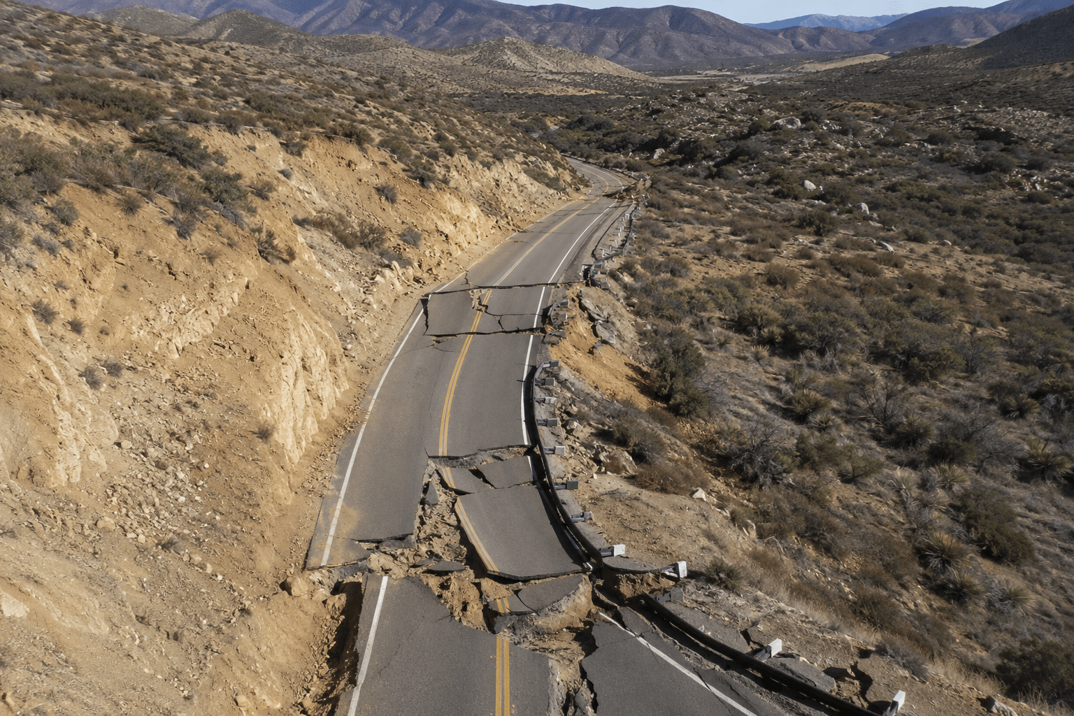
Yet beneath the highways, suburbs, industrial corridors, and sprawling neighborhoods of Southern California, researchers believe a dangerous geological process may be quietly approaching a critical stage. Recent studies examining the interaction between two of the region’s most active fault systems have identified a narrow section of mountainous terrain northeast of Los Angeles where immense tectonic forces appear to be accumulating. Known as the Cajon Pass, this rugged corridor functions as one of Southern California’s most important transportation gateways, carrying major interstate highways, freight rail lines, energy infrastructure, and communication networks that connect the Los Angeles Basin with the rest of the country.
What makes the Cajon Pass especially significant is not its strategic importance above ground, but the complex network of faults hidden deep below it. This is the location where the San Andreas Fault and the San Jacinto Fault converge more closely than almost anywhere else in California. According to researchers, this area may function as an “earthquake gate,” a geological trigger point capable of determining whether a future seismic event remains confined to a single fault or spreads into a far larger rupture involving multiple fault systems simultaneously.
The distinction between those two scenarios could define the scale of destruction across Southern California for generations to come. A major earthquake occurring along a single fault line would already rank among the most devastating natural disasters in modern American history. A rupture that jumps from one fault system to another, however, could unleash a chain reaction capable of producing far more extensive damage across a region home to nearly twenty-four million people.
For decades, earthquake models largely treated major faults as separate structures, each capable of generating destructive events independently. Modern research paints a far more unsettling picture. Scientists increasingly understand that fault systems behave like interconnected networks, transferring stress and energy across vast distances over centuries. Pressure does not build evenly beneath the Earth’s crust. It shifts, migrates, concentrates, and redistributes itself after every seismic event, creating patterns that can remain hidden for generations before revealing themselves through catastrophic ruptures.
Researchers studying Southern California reconstructed more than a thousand years of seismic history using geological evidence, radiocarbon dating, historical records, and even anomalies preserved in tree rings. This data was incorporated into sophisticated four-dimensional computer models designed to simulate how stress has accumulated and evolved across the region over time. Rather than focusing on individual faults in isolation, scientists examined the entire fault system as a dynamic network, tracing how previous earthquakes altered the distribution of tectonic pressure beneath Southern California.
The results were alarming. According to the study, the San Jacinto–San Bernardino section has reached stress levels of approximately 3.6 megapascals, the highest values identified anywhere within the model’s thousand-year simulation. At the same time, the nearby Mojave South segment of the San Andreas Fault is also showing unusually elevated levels of accumulated stress. Independently, each finding would already warrant close scientific attention. Together, they suggest that two major fault systems may be entering a configuration that has historically preceded larger and more complex ruptures.
Scientists remain careful to emphasize that these findings do not constitute a prediction. Modern seismology cannot determine the exact day, month, or even year when an earthquake will occur. Despite enormous advances in geological modeling and monitoring technology, no reliable method exists for forecasting the precise timing of a major seismic event. What researchers can identify are the conditions that increase the probability of larger earthquakes occurring over time, and according to the latest models, those conditions may now be reaching levels unseen in at least a millennium.
The danger extends far beyond the immediate effects of violent ground shaking. Southern California relies on an extraordinarily complex web of infrastructure that was built across one of the most seismically active regions on Earth. Interstate highways cut through mountain passes and densely populated urban corridors, while freight rail networks connect the ports of Los Angeles and Long Beach to supply chains stretching across North America. Water imported from distant reservoirs travels through aqueducts crossing active fault zones, while fuel pipelines, electrical grids, internet cables, hospitals, airports, and emergency response centers depend on systems designed to function continuously without interruption.
A sufficiently large multi-fault rupture would not simply damage these networks; it could trigger cascading failures across multiple sectors simultaneously. Bridges and overpasses could become impassable within minutes. Water mains could rupture beneath city streets while power outages leave millions without electricity. Communication systems could become overloaded precisely when emergency services need them most, and transportation corridors essential for delivering medical supplies, fuel, and food could be cut off across vast areas.
Although emergency management agencies maintain extensive disaster response plans, their effectiveness depends heavily on the scale of the event. A localized earthquake can be addressed through the rapid deployment of rescue teams and logistical support. A regional catastrophe affecting millions of people at once presents a far more difficult challenge. Damaged infrastructure, blocked evacuation routes, and disrupted communication networks could significantly delay response efforts during the critical first hours following the disaster.
Recent emergencies across California, including devastating wildfire seasons and infrastructure failures during periods of extreme weather, have repeatedly exposed vulnerabilities in evacuation planning and emergency coordination. Communities connected by narrow mountain roads remain particularly difficult to evacuate quickly, while decades of rapid urban expansion have placed increasing pressure on aging infrastructure. Despite billions of dollars invested in retrofitting bridges, hospitals, and public buildings, many critical systems were never designed to withstand the consequences of a worst-case multi-fault rupture.
This gap between scientific awareness and practical preparedness remains one of the most troubling aspects of California’s seismic risk. For many residents, the threat of the Big One still feels abstract because daily life continues uninterrupted. Yet seismologists have long warned that periods of relative quiet do not necessarily indicate stability. In some cases, they may signal the opposite: the gradual accumulation of tectonic stress deep beneath the surface. Unlike hurricanes, wildfires, or floods, earthquakes provide no visible warning signs. There are no darkening skies, no evacuation orders issued days in advance, and no reliable countdown to impact. The forces responsible operate silently, storing energy over decades and centuries until geological conditions align and release that energy within seconds.
Above ground, millions of people continue their routines without noticing the immense pressures building beneath them. Freight trains move through the Cajon Pass around the clock. Commuters drive crowded highways every morning. Children attend school, businesses operate as usual, and entire cities remain illuminated by infrastructure crossing active fault zones. Deep below the surface, however, two of California’s most dangerous fault systems continue their slow and relentless movement toward an uncertain future, accumulating forces that researchers now believe may be approaching levels not seen in more than a thousand years.
For much of the twentieth century, California’s earthquake threat was viewed through a relatively simple lens: a single fault would rupture, damage would be concentrated within a defined region, and recovery efforts would begin as soon as the shaking stopped. That understanding shaped everything from building codes and insurance models to emergency response strategies and public awareness campaigns. The possibility that multiple fault systems could interact during the same event was acknowledged by some researchers, but the technology needed to simulate those interactions in meaningful detail simply did not exist.
Over the last decade, however, advances in computational modeling, geological mapping, and seismic monitoring have fundamentally changed the way scientists understand earthquake dynamics. Faults are no longer seen as isolated fractures buried beneath the Earth’s surface. They are increasingly understood as components of a larger, interconnected system in which stress continuously moves from one region to another. Every earthquake alters the surrounding geological environment, redistributing pressure across neighboring faults and creating conditions that may influence future ruptures decades or even centuries later.
This evolving understanding has placed renewed focus on the relationship between the San Andreas Fault and the San Jacinto Fault, two of the most active and closely monitored fault systems in Southern California. The San Andreas Fault, stretching roughly 800 miles across the state, marks the boundary between the Pacific and North American tectonic plates and has long been considered the primary source of California’s greatest seismic threats. Running parallel to sections of the San Andreas, the San Jacinto Fault has historically generated frequent earthquakes and is often described by geologists as one of the most seismically active fault zones in the region.
What concerns researchers is not simply the behavior of these faults individually, but the possibility that accumulated stress along one system could influence the other. The Cajon Pass represents a critical point where these enormous geological structures come into close proximity, creating conditions that may allow seismic energy to transfer between them during a major rupture. In practical terms, this means that an earthquake beginning on one fault could potentially trigger movement on another, dramatically increasing both the magnitude of the event and the area affected by its impacts.
Recent simulations suggest that this scenario is more than a theoretical possibility. By reconstructing a thousand years of seismic history, researchers discovered that current stress levels in key sections of both fault systems are unusually high. More importantly, the distribution of that stress appears to resemble patterns associated with larger historical ruptures. Scientists emphasize that these findings should not be interpreted as evidence that a catastrophic earthquake is imminent. Instead, they represent a warning that the geological conditions necessary for a more complex and destructive event may be developing beneath Southern California.
The implications extend far beyond earthquake science. Southern California is one of the world’s largest urban regions, home to critical infrastructure that supports not only the state economy but also national and international supply chains. The ports of Los Angeles and Long Beach handle a substantial share of goods entering the United States, while extensive rail and highway networks distribute those products across the country. Fuel pipelines, electrical transmission lines, telecommunications infrastructure, and water delivery systems all intersect with active fault zones at multiple points.
A large multi-fault rupture could create simultaneous failures across these interconnected networks, turning a regional disaster into a national economic crisis. Experts have repeatedly warned that modern infrastructure systems are highly efficient under normal conditions but often lack the redundancy needed to withstand widespread disruption. When transportation routes are severed, power grids damaged, and communication networks overloaded at the same time, recovery efforts become significantly more difficult.
Historical earthquakes offer only limited guidance because Southern California has never experienced a disaster of this scale in the modern era. The 1994 Northridge earthquake caused approximately $50 billion in damages despite affecting a relatively confined area. The 1906 San Francisco earthquake and resulting fires devastated an entire city, but California’s population at the time was a fraction of what it is today. Millions of people now live in areas that did not exist during previous major earthquakes, relying on infrastructure networks of unprecedented complexity.
This reality has forced emergency planners to reconsider long-held assumptions about disaster response. Traditional models often assume that unaffected regions can provide support to impacted areas, sending personnel, equipment, and supplies where they are needed most. A large multi-fault earthquake affecting Southern California could overwhelm those assumptions by damaging multiple counties simultaneously and disrupting the very transportation corridors required for emergency operations.
The first seventy-two hours following such an event would likely be defined by uncertainty. Emergency services could struggle to reach isolated communities due to collapsed overpasses, damaged roads, or debris blocking critical routes. Hospitals might face overwhelming demand while operating on backup power systems. Water shortages could develop rapidly if major pipelines or aqueducts are damaged, while interruptions to fuel distribution networks could complicate rescue efforts and delay the movement of essential supplies.
For residents, the experience would extend beyond the immediate violence of the earthquake itself. The psychological impact of prolonged uncertainty, limited communication, and disrupted access to basic necessities often defines the aftermath of major disasters. Studies conducted after previous earthquakes have consistently shown that secondary effects, including displacement, economic hardship, and infrastructure failures, can persist for months or even years after the initial event.
The unsettling aspect of the current research is not that scientists have identified a specific date for a future earthquake, but that they have identified a pattern. Deep beneath Southern California, geological forces continue to accumulate along fault systems that have remained relatively quiet for extended periods. While silence is often interpreted as reassurance, seismologists understand that it can sometimes indicate the opposite. Tectonic plates do not stop moving simply because the ground above them feels still. The immense pressures generated by that movement continue to build, hidden beneath cities, highways, and communities that have grown increasingly dependent on uninterrupted infrastructure.
Every day without a major earthquake feels like proof that the system is stable. In reality, the absence of visible warning signs is one of the most dangerous aspects of seismic risk. The forces involved operate on timescales far removed from human experience, storing energy over centuries before releasing it in a matter of seconds. According to the latest models, the region surrounding the Cajon Pass may now be carrying more accumulated stress than at any other point in the past thousand years, a finding that has transformed an already familiar threat into something far more difficult to ignore.
The possibility of a multi-fault earthquake has forced scientists to confront an uncomfortable truth: California’s greatest seismic threat may not come from a single catastrophic rupture, but from a sequence of interconnected failures capable of amplifying one another in ways that previous generations of researchers could barely model. The concept of an “earthquake gate” at the Cajon Pass reflects this growing understanding. It is not a prediction of a specific event, nor does it suggest that disaster is imminent. Instead, it highlights a critical point within Southern California’s fault network where geological conditions may allow stress to transfer between two major systems, creating the potential for a rupture far larger than anything either fault could produce alone.
This concern becomes even more significant when viewed against California’s recent seismic history. The southern section of the San Andreas Fault has not experienced a major rupture since approximately 1690, meaning that more than three centuries of tectonic movement have continued to accumulate strain along parts of the fault. In geological terms, this prolonged period of relative quiet is not necessarily reassuring. The Pacific Plate continues to move northwest relative to the North American Plate at a rate of roughly two inches per year, a seemingly insignificant motion that gradually stores enormous amounts of energy beneath the surface.
Unlike other natural hazards, earthquakes provide no gradual escalation that allows communities to adapt as conditions worsen. Wildfires often begin as visible smoke plumes before expanding into large-scale emergencies. Hurricanes can be tracked for days as they move across oceans. Floods typically follow identifiable weather patterns and rising water levels. Earthquakes offer no such warning. The first indication that something has gone wrong is often the event itself, unfolding within seconds and leaving little time for meaningful action.
The challenge facing Southern California is compounded by the fact that much of its critical infrastructure was designed around assumptions that may no longer reflect current scientific understanding. Many transportation corridors, utility networks, and communication systems were built with the expectation that earthquake impacts would remain relatively localized. A rupture involving multiple fault systems could expose vulnerabilities that were never fully considered during the design process.
The Cajon Pass illustrates this risk with remarkable clarity. Interstate 15, one of the most important transportation routes in the western United States, passes directly through the region. Freight rail lines carrying consumer goods from the ports of Los Angeles and Long Beach run alongside energy transmission corridors that connect Southern California to neighboring states. Damage to this narrow but essential gateway could disrupt supply chains extending far beyond California, affecting fuel distribution, manufacturing operations, and retail networks across the country.
Water infrastructure presents another significant concern. Southern California depends heavily on imported water transported through aqueducts, pumping stations, and pipelines that cross active fault zones. A major earthquake could damage these systems at multiple points simultaneously, creating shortages that would complicate rescue operations and recovery efforts. Electrical grids face similar vulnerabilities, particularly as demand continues to increase across rapidly growing urban areas.
While engineers have invested billions of dollars in seismic retrofitting projects over the past several decades, experts acknowledge that complete protection is impossible. Retrofitting reduces risk; it does not eliminate it. Many older buildings remain vulnerable, particularly structures constructed before modern earthquake standards were introduced. Even newer buildings designed to withstand significant shaking may suffer non-structural damage severe enough to disrupt their operation for weeks or months.
Hospitals, schools, emergency operations centers, and transportation hubs have received priority attention, yet their ability to function depends on a broader network of supporting infrastructure. A hospital can remain standing after a major earthquake and still struggle to provide care if roads are impassable, communication systems fail, or water and electricity supplies are interrupted. Resilience depends not only on the strength of individual buildings but also on the reliability of the systems connecting them.
Emergency preparedness campaigns have long encouraged Californians to maintain supplies capable of sustaining households for at least several days without outside assistance. Water, food, medications, flashlights, batteries, and communication plans remain essential components of personal preparedness. Despite these recommendations, surveys consistently indicate that many residents remain underprepared for a major earthquake, often assuming that emergency services will arrive quickly regardless of the scale of the disaster.
Recent events have repeatedly demonstrated the limitations of that assumption. Wildfires, power outages, and extreme weather have shown how rapidly critical systems can become overwhelmed when multiple disruptions occur simultaneously. A major earthquake affecting several counties at once could create conditions far more challenging than anything California has experienced in recent decades.
The most unsettling aspect of the current research is its reminder that the forces shaping Southern California’s future remain largely invisible. There are no visible cracks spreading across highways, no dramatic warning signs appearing on mountain slopes, and no reliable indicators that an earthquake is days or weeks away. Millions of people continue their routines above a landscape that appears stable and familiar, unaware of the slow geological processes unfolding deep beneath their feet.
Beneath the cities, freeways, and suburbs of Southern California, tectonic plates continue their relentless movement, generating pressures that build incrementally year after year. Scientists cannot say when those pressures will ultimately be released, but the latest models suggest that the underlying conditions deserve closer attention than ever before. The region surrounding the Cajon Pass has emerged as a focal point in that research because it represents more than a simple intersection of fault lines. It is a reminder that the greatest threats are often the ones that develop silently, beyond the limits of human perception, accumulating strength long before their consequences become impossible to ignore.
For now, California remains suspended between scientific uncertainty and geological inevitability. The ground is still. The highways remain crowded. Freight trains continue to move through the Cajon Pass day and night, carrying goods that support one of the world’s largest economies. Daily life proceeds uninterrupted, creating the comforting illusion that stability and safety are the same thing.
Deep underground, however, the Earth’s immense tectonic machinery continues to operate according to timescales measured not in days or years, but in centuries. And according to the latest research, the stress accumulating beneath Southern California may already have reached levels that researchers have not observed in more than a thousand years.


That’s definitely one of the problems that will be devastating during and before the great tribulation, and here is another one that will make it even worse. https://www.armstrongeconomics.com/world-news/war/russias-new-warning-shot-from-space/
LikeLike